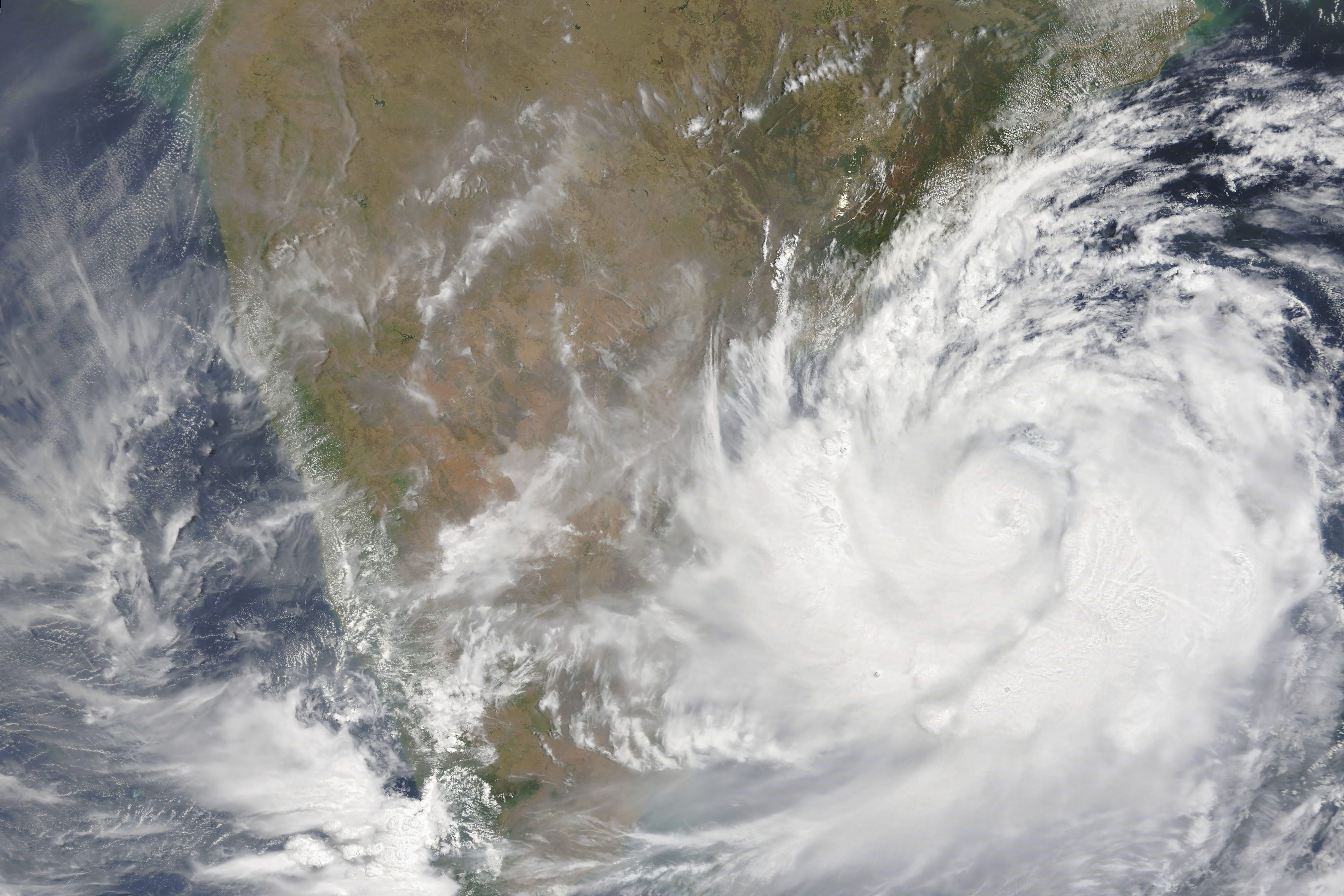
The extremely severe cyclonic storm Fani will make landfall today morning around 9.30 am in Odisha's Puri, much before the earlier forecast of 3 pm. With a few hours left for cyclone Fani to hit the coast, a massive exodus got under way in coastal Odisha as hundreds of thousands of people left their home, on foot and by vehicles, in probably the largest evacuation ahead of a natural disaster in the country. The Odisha government has moved 11 lakh people to safety and advised the public to remain indoor on Friday. Fani is being regarded as the most severe cyclonic storm since the super cyclone of 1999 that claimed close to 10,000 lives and left a trail of destruction in vast swathes of the state, according to the Joint Typhoon Warning Centre. Fani, according to sources, has gathered speed and is rolling dangerously towards the coast clocking 17 km per hour. After crossing Odisha, cyclone Fani is likely to move towards West Bengal before tapering off. It is, however, still likely to impact parts of the northeast, Andhra Pradesh and Tamil Nadu. There is forecast of massive tides that could surge up to 1.5 metres during the landfall, officials said. Fishermen have been advised against venturing into the sea.
Here are the live updates on Cyclone Fani:
Digha: Fishermen prohibited from venturing into the sea, asked to vacate the seashore & move to relief centre. Fisherman Sujit Muiya says, "We're scared. Safety is our priority but once cyclone goes away, we'll need to earn money. Can't bear damage of my fishing net." #WestBengal pic.twitter.com/VJYn5zdelu
- ANI (@ANI) May 3, 2019
Latest Radar pics indicate slight weakening in convection of wall cloud region. pic.twitter.com/PGjKzdtYas
- India Met. Dept. (@Indiametdept) May 2, 2019
While #ExtremelySevereCyclonicStorm #FANI lay centered 170 kms ENE of #Vishakhapatnam @IndiaCoastGuard positions 34 Disaster Relief Teams #DRTs at #Vizag #Chennai #Paradip #Gopalpur #Haldia #Frazergunj & #Kolkata besides 04 #CoastGuard ships at #Vizag & #Chennai @DefenceMinIndia pic.twitter.com/yRH4dmCKgW
- Indian Coast Guard (@IndiaCoastGuard) May 2, 2019
Extremely Severe Cyclonic storm FANI is located about 200 km SSW of Puri .To cross Odisha coast between Gopalpur and Chandbali to the south of Puri during 3rd May F/N with maximum sustained wind speed of 170-180 kmph . Landfall process continue till noon/afternoon of 3rd May. pic.twitter.com/VMr2I1I84h
- India Met. Dept. (@Indiametdept) May 2, 2019

CMO Odisha: CM Naveen Patnaik visited Special Relief Organisation office to review preparedness, and appealed to people to remain indoors until #CycloneFani passes & advised all officials to make their best efforts to face the cyclone. pic.twitter.com/wfZGPw0adD
- ANI (@ANI) 2 May 2019

Odisha State Disaster Management Authority has said that Cyclone Fani will make a landfall tomorrow likely between 12pm to 2pm. Earlier, the landfall was expected at 5.30 pm tomorrow.
Sangram Mohapatra, Spokesperson, Odisha State Disaster Management Authority: Landfall which was expected to be at 5:30 pm tomorrow, is now expected between 12 pm-2 pm. All colleges & soft business establishments will be closed tomorrow. #CycloneFani pic.twitter.com/amaHWsbRWM
- ANI (@ANI) 2 May 2019
All airlines are requested to offer all assistance for rescue and relief operations in view of #CyclonicStormFANI All relief material should be airlifted to be delivered to officially designated agencies We all in #aviation sector must rise to occasion.Controll room being set up
- Chowkidar Suresh Prabhu (@sureshpprabhu) 2 May 2019
Rain lashes Podugupadu village in coastal district of Srikakulam.
- NDTV (@ndtv) 2 May 2019
It is one of the four districts of Andhra Pradesh expected to be affected by #CycloneFani (news agency ANI) pic.twitter.com/Vyh51UllUL
Prime Minister Narendra Modi today reviewed the preparedness for cyclone Fani and instructed government officials to maintain close coordination with officials of the affected states to ensure preventive measures. PM Modi also asked the concerned officers to take effective steps for relief and rescue operations, as required. The Prime Minister was briefed on the likely path of the cyclone, and the ongoing precautionary and preparatory measures being undertaken.
Chaired a high level meeting to review the preparedness relating to Cyclone Fani. The Central Government is ready to provide all possible assistance that would be required.
- Chowkidar Narendra Modi (@narendramodi) 2 May 2019
Prayers for the safety and well-being of our citizens. pic.twitter.com/GLoCzmV1io
Odisha: Preparation underway at Red Cross Bhavan in Bhubaneswar for distribution of relief material packets. #CycloneFani pic.twitter.com/NNe3RJhzYc
- ANI (@ANI) 2 May 2019
Odisha: People at Puri beach being warned against venturing into the sea as #CycloneFani is expected to make landfall in Puri district tomorrow. pic.twitter.com/HJXGhbFwQl
- ANI (@ANI) May 2, 2019
IG Coast Guard East: We have positioned 8 rescue teams, 4 each at Visakhapatnam & Chennai. We have also kept 2 ships each at Visakhapatnam&Chennai for immediate mobilisation post-cyclone. One Chetak helicopter, each at Chennai&Visakhapatnam is kept ready to provide relief. #Fani https://t.co/FkVXtYsdZd
- ANI (@ANI) May 2, 2019
About 8 lakh people are being moved to safety by #Odisha Government into about 880 multipurpose cyclone/flood shelters with arrangements for free kitchen, safe drinking water, lighting, health and sanitation. #OdishaPrepared4Fani
- CMO Odisha (@CMO_Odisha) 2 May 2019
https://t.co/kC1M5hLjqs
All authorities concerned have been alerted so that they are ready to deal with cyclone Fani, Civil Aviation Minister Suresh Prabhu said Thursday.
Fani is expected to hit the Odisha coast on Friday. Other states on the eastern coast, such as West Bengal, Andhra Pradesh and Tamil Nadu are also expected to be affected by it.
"Alerted all concerned to be ready to deal with Cyclone Fani. Airport Authority of India issued alert to all coastal airports to ensure all precautions, SOPs (standard operating procedures) put in place immediately," Prabhu tweeted.
#CycloneFani: A cyclone can be devastating. Follow these do's and don'ts of a #cyclone before it inflicts heavy damage to your region. pic.twitter.com/ZfO6Hrc7Kt
- NDMA India (@ndmaindia) May 1, 2019
 Odisha Braces For Fani (Foni), Worst Since 1999 Super Cyclone That Killed 10,000
Appeal to all Don't Panic! Stay safe and help each other during #CycloneFani . my sand art at #Puri beach in #Odisha . pic.twitter.com/dIYEo7tVTK
- Sudarsan Pattnaik (@sudarsansand) May 2, 2019
Mobilization of 180 expecting mothers in Ganjam district has been done as a precautionary measure for #CycloneFani. @CMO_Odisha @SRC_Odisha pic.twitter.com/1ZEADdrKYF
- H & FW Dept Odisha (@HFWOdisha) May 1, 2019
#CycloneFani: A cyclone can be devastating. Follow these do's and don'ts of a #cyclone before it inflicts heavy damage to your region. pic.twitter.com/ZfO6Hrc7Kt
- NDMA India (@ndmaindia) May 1, 2019
 Cyclone Fani: Odisha Braces For Storm, 103 Trains Cancelled So Far
Railways has cancelled at least 103 trains in light of cyclone "Fani", which is likely to affect 19 districts of Odisha, Andhra Pradesh and West Bengal, besides Kolkata."
Extremely Severe Cyclonic Storm FANI about 450 km south-southwest of Puri at 0530 hrs IST of 02nd May, 2019. To cross Odisha coast around Puri by afternoon of 3rd May. https://t.co/wRl94BRtm1 pic.twitter.com/nzGmV2Jr6O
- India Met. Dept. (@Indiametdept) May 2, 2019
Appeal to all Don't Panic! Stay safe and help each other during #CycloneFani . my sand art at #Puri beach in #Odisha . pic.twitter.com/dIYEo7tVTK
- Sudarsan Pattnaik (@sudarsansand) May 2, 2019
Extremely Severe Cyclonic Storm FANI about 540 km south-southwest of Puri at 2330 hrs IST of 01st May, 2019. To cross Odisha coast around Puri during 3rd May. https://t.co/wRl94BRtm1 pic.twitter.com/zl6CCRUMBK
- India Met. Dept. (@Indiametdept) May 1, 2019
Cyclone Fani, which has turned into an "extreme severe cyclonic" storm, is about 540 km from the Odisha coast, the India Meteorological Department or IMD said in an early morning tweet. The cyclonic storm is moving northwards with a speed of 5 kms per hour in last six hours and is likely to make landfall at Odisha coast between Gopalpur and Chandbali, on May 3 with wind speed of up to 200 km per hour.

