

| State - Odisha | |||||||||||||
| Abstract of Status Report on Cyclone "PHAILIN" followed by Flood | |||||||||||||
| [As on Dt.17/10/2013] : 10.00 AM | |||||||||||||
| Sl. | Name of the districts | Blocks Affected (Nos.) | GPs Affected (Nos.) | Villages Affected (Nos.) | ULB Affected (Nos.) | Population Affected (Nos.) due to flood & cyclone | Human Casulaty due to cyclone | Human Casulaty due to flood | Crop area affected (in hect.) | Person evacuated due to cyclone | Person evacuated due to flood | Cattle evacuated | Houses Damaged |
| 1 | 2 | 3 | 4 | 5 | 6 | 7 | 8 | 9 | 10 | 11 | 12 | 13 | 14 |
| 1 | Angul | 8 | 589 | 1 | 1 | 2829 | |||||||
| 2 | Balasore | 11 | 125 | 1725 | 4 | 348778 | 3 | 5 | 67800 | 4185 | 126842 | 2771 | |
| 3 | Bhadrak | 6 | 52 | 179 | 1 | 145000 | 1 | 1 | 43974 | 48202 | 5040 | ||
| 4 | Bolangir | 5 | 1 | 1 | 35000 | 119 | |||||||
| 5 | Cuttack | 800 | 1553722 | 19950 | 114306 | 7225 | 10174 | ||||||
| 6 | Gajapati | 7 | 129 | 1528 | 2 | 480300 | 21140 | 36960 | 25 | 15000 | |||
| 7 | Ganjam | 22 | 475 | 2812 | 18 | 1502000 | 10 | 216100 | 180000 | 4221 | 230000 | ||
| 8 | Jagatsinghpur | 8 | 186 | 1230 | 2 | 900000 | 1 | 12650 | 101457 | 9028 | 4883 | ||
| 9 | Jajpur | 10 | 280 | 1813 | 2 | 630000 | 14128 | 91131 | 6900 | 1088 | 3843 | ||
| 10 | Kandhamal | 10 | 45 | 124 | 1 | 13310 | 1 | 302 | 13310 | 6210 | |||
| 11 | Kendrapara | 9 | 230 | 1592 | 2 | 1445891 | 1 | 13835 | 59550 | 973 | |||
| 12 | Keonjhar | 13 | 263 | 65123 | 1 | 32530 | 11825 | 12569 | |||||
| 13 | Khurda | 10 | 15 | 1355 | 2 | 2234706 | 1 | 1 | 49359 | 185291 | 2586 | 42131 | |
| 14 | Koraput | 2 | 19 | 3860 | |||||||||
| 15 | Mayurbhanj | 11 | 68 | 737 | 2 | 342260 | 5 | 52000 | 37341 | ||||
| 16 | Nayagarh | 8 | 180 | 1582 | 2 | 984000 | 34340 | 31565 | 56 | 24808 | |||
| 17 | Puri | 11 | 230 | 1769 | 4 | 1750975 | 3 | 1 | 55160 | 102000 | 820 | 63715 | |
| TOTAL | 151 | 2015 | 18117 | 43 | 12396065 | 21 | 17 | 668268 | 983642 | 171083 | 31062 | 419052 | |
| * | Casualty of large animal - 1487, small animal - 2906 and birds - 170970, Carcass disposal completed | ||||||||||||
| * | 5.7 tons of dry food air dropped | ||||||||||||
1.2 crore people in 16,000 villages affected
Chief Minister Naveen Patnaik does aerial survey of affected districts
Balasore, Jajpur, Bhadrak, Mayurbhanj districts affected
Over 75,000 people still marooned in Balasore and Jajpur districts
Standing crops in over six lakh hectares destroyed
Over three lakh houses damaged due to floods and cyclone
Over 11 lakh evacuated in all
Water level receding in Budhabalang in Balasore
Food packets are being air-dropped
Relief to be sent by boats to flood-hit areas
Odisha:
- NDRF teams have cleared 1096 kms of road by removing 937 fallen trees. Around 45electric poles also cleared.
- Most of the important roads opened and made motorable
- Total 83 persons were rescued from Kavitri mandal, Ganjam and Jagatsinghpur
- Total 1015 persons were rescued from district Balasore, Odisha
- Total 49 persons evacuated and shifted to safer places from villages- Alipur and Patharagara in district Ganjam
- Total 230 persons were rescued from district Mayurbhanj in Odisha
- Total 20 persons were rescued from district Keonjhar in Odisha
- Total 5 persons were rescued from district Jajpur, Odisha
- Total 120 persons rescued from Raghunathpur and Banki area of district Cuttack
- 14 Quintal relief material distributed in district Balasore and Ganjam
- NDRF teams distributed food packets to 400 persons at Behram, district Ganjam
Bihar and Jharkhand:
- 4 NDRF teams are prepositioned at Supaul, Sitamarhi ,Darbhanga and Gopalganj in connection with prevailing flood like situation
- 2 NDRF teams are prepositioned at Jamsedpur and Dhanbad
- 2 Teams of NDRF are prepositioned at Bhara/Nariyal/ collectriate Ghat, Patna and Purnia
- 2 NDRF teams are being kept as reserve at Supaul.
The Prime Minister reviewed the impact of Cyclone Phailin and the damage caused by it in Odisha, Andhra Pradesh and other areas.
The Prime Minister is relieved to learn that, even though Cyclone Phailin was a very severe cyclonic storm, the loss of life has been contained to a very large extent because of the preventive measures taken in advance. However, the Prime Minister noted with distress the extensive damage to property, crops and livestock that has resulted from the cyclone. The Prime Minister expressed his sympathies for those who have lost their near and dear ones or have lost their houses, crops or livestock.
The Prime Minister complimented the efforts of the state authorities, district and police administration in all the affected districts, relief workers at the state and district levels, the officers and staff of the National Disaster Management Authority, the National Disaster Relief Force and the Indian Meteorological Department, for the preventive measures they took which resulted in containing the effects of the cyclone on human life.
The Prime Minister announced an ex-gratia assistance of Rs.2,00,000 to the next of kin of each of the deceased and Rs.50,000 to those seriously injured in the cyclone, from the Prime Minister's National Relief Fund.
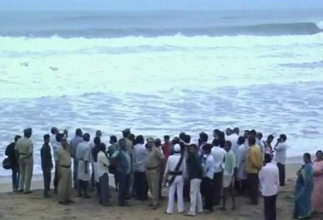
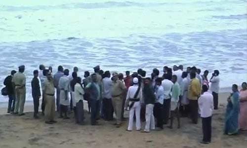
Villagers protest on road from Bhubaneswar to Bhanjanagar demanding relief. Roads have been blocked with tree trunks. A sub divisional collector was also present.
 Cyclone Phailin shifts to Jharkhand, to weaken to a low pressure
After leaving a trail of destructions and keeping the state administration on its toes for over a week, the cyclone Phailin has finally left Odisha and shifted to neighbouring Jharkhand as a depression, Met office sources said.
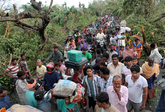
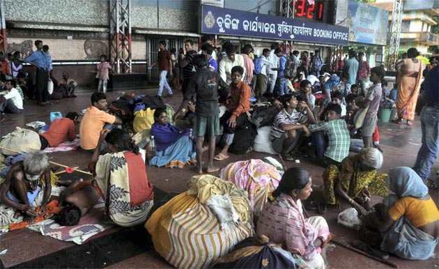
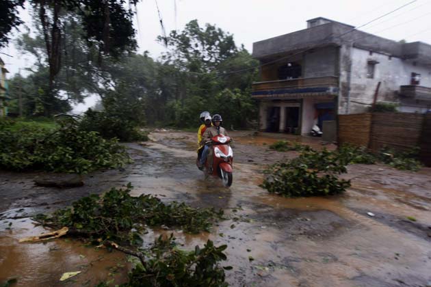
 Over two lakh marooned due to floods in Odisha, situation 'critical'
Heavy rains in the aftermath of Cyclone Phailin, which struck the Odisha coast over the weekend and has since dissipated, has triggered massive floods in several districts in the state. Over 2.5 lakh people have been marooned in Balasore, which along with Mayurbhanj, are the worst-hit.
- 10,000 people stranded in floods in Ganjam in Odisha
- Three villages completely cut off
- Rivers Baramadi and Nohrakhandi are in spate, water receding slowly
- Local MLA P Swain says Army and Air Force need to be called in
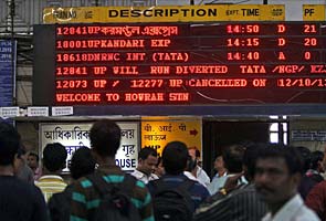 Cyclone Phailin forces Railways to cancel, reschedule trains
The South Eastern Railway today cancelled the Howrah-Puri Weekly Express, and rescheduled or diverted some other train services following the cyclonic storm Phailin which threw train traffic out of gear since Saturday.
- The severe cyclone was predicted exactly, the track, the intensity were predicted exactly. These predictions warn people.
- The 16-17 people who died were caught in post cyclone accidents, they didn't die during the cyclone.
- Nearly a million people were evacuated. Mostly in Odisha.
- In terms of the numbers involved in the evacuations, this is a world record. This is because we made strategic investments in our Met dept. Though it was only 750 cr.
- The ability of our Met department to accurately predict even rains has improved. It's a blessing for farmers.
- Our nation can congratulate itself. No other South Asian country has the kind of equipment we do. If we make more investments, we can be equal to the best in the world.
- I'd like to congratulate the staff, thank the Home Ministry. The state administrations did a very good job too
- Khudra road, Berhampur, Palasa, Srikakulam, and Visakhapatnam routes opened for traffic
- Train services to south India and Mumbai from Bhubaneswar fully restored
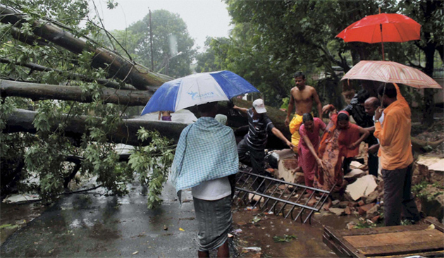
 Cyclone Phailin leaves a trail of destruction
 An unprecedented and timely evacuation drive, said to be biggest ever in India, ensured minimum casualties as Cyclone Phailin slammed into coastal Odisha.
- People stranded near Chandipur in Odisha
- 15,000 food packets to be dropped
- 4 Mi-17 helicopters pressed into service for flood relief
One column of army engineers deployed at 11 PM yesterday night for flood relief 100 west of Ganja. Rivers like Mahanadi and Subernarekha are in spate.
Time of issue: 0230 hours IST Dated: 14-10-2013
Bulletin No.: BOB 04/2013/42
Subject: Cyclonic Storm 'PHAILIN' remained as deep depression over north Chhattisgarh and
adjoining Jharkhand.
The cyclonic storm, PHAILIN remained as deep depression over north Chhattisgarh and adjoining areas of Odisha & Jharkhand and moved northwards with a speed of 16 kmph during past 6 hours and lay centred at 2330 hours IST of 13 th October 2013 over Jharkhand and adjoining north Chhattisgarh near latitude 23.5 0 N and longitude 83.8 0 E, 70 km north-east of Ambikapur & 60 km southeast of Daltonganj. The system would move north-northeastwards during next 6-12 hours and weaken gradually into a depression.
Estimated track and intensity of the system are given in the Table below:
Date/Time (IST) Position Sustained maximum surface Category
(Lat. 0 N/ Long. 0 E) wind speed (kmph)
13-10-2013/2330 23.5/83.8 40-50 gusting to 60 Deep Depression
14-10-2013/0530 24.0/84.3 35-45 gusting to 55 Depression
14-10-2013/1130 24.7/84.6 25-35 gusting to 45 Well Marked Low Pressure Area
Warning for Jharkhand, Bihar, Sub-Himalayan West Bengal & Sikkim
Heavy rainfall: Rainfall at many places with isolated heavy to very heavy falls would occur over Bihar, Sub-Himalayan West Bengal & Sikkim during next 36 hours and in Jharkhand during next 24 hours.
Rainfall at many places with isolated heavy falls would occur over north Chhattisgarh and interior Odisha during next 12 hrs.
Squally wind: Squally wind speed of 40-50 kmph gusting to 60 kmph would prevail around system centre during next 6 hours and would gradually decrease thereafter.
 Cyclone Phailin moves inland, flood threats in Chhattisgarh, Bihar
With Cyclone Phailin moving further inland, there is flood threat in Mayurbhanj and Baripada districts of Odisha and neighbouring states of Chhattisgarh, Jharkhand and Bihar.
 Cyclone Phailin kills 23, mass evacuations save thousands
An unprecedented evacuation drive, said to be the country's biggest ever, ensured minimum casualties as Cyclone Phailin slammed into coastal Odisha on Saturday. 23 people, including 2 in neighbouring Andhra, have died in the aftermath of the "very severe" storm, which has since weakened.
 Cyclone Phailin: Kaviti, one of the worst hit in Andhra Pradesh
Though Andhra Pradesh suffered one cyclone related death, the destruction has been immense. For Saralamma, a widow and mother of two, life has almost come to a standstill with her house collapsing due to the strong winds.
 Cyclone Phailin: India's biggest evacuation op ever
There's minimal loss of life in Cyclone Phailin after 9 lakh people are evacuated in 36 hours following the Met dept's accurate forecast. We debate: Has India's disaster preparedness finally come of age?
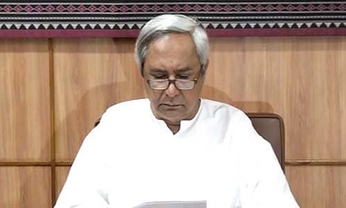
 First priority was to save precious lives: Odisha Chief Minister to NDTV
Odisha Chief Minister Naveen Patnaik said that his government's "first priority was to save precious human lives and to a great extent we have achieved that". He also thanked the entire state administration as well as the Navy and Army for mounting the mammoth rescue and relief operations.
- IMD has done an excellent job
- Great coordination between various agencies
- Cyclone currently near Odisha-Chhattisgarh border
- Wind speeds of 55-65 kmph gusting upto 75 kmph for the next six hours
- Thereafter, winds speeds will come down to 40-50 kmph
- Very heavy rains predicted in Bihar on 14th & 15th
- NDRF on stand-by for any flood situation in Bihar
- Cyclone will move to Bihar after crossing Bihar, and rains there will most likely flood the Kosi river coming to Bihar
- 13 deaths in Odisha and one death reported in Andhra Pradesh, have been able to... (keep) the death toll to a bare minimum
- Out of these deaths, six happened day before yesterday due to trees falling in Ganjam district in Odisha
 Cyclone Phailin: work to restore damaged infrastructure starts
With the intensity of Cyclone Phailin subsiding, steps to restore snapped communication lines, power transmission and rebuild damaged infrastructure in coastal belt of Odisha and Andhra Pradesh started today.
Coast Guard ship Samudra Paheredar, Vajra out at sea
Three Dorniers deployed
18 stranded fisherman rescued at Paradip
Third Dornier sortie on
 Crew of missing cargo ship located, no casualties reported
Crew members of the MV Bingo, a China-bound merchant vessel which lost contact with the ground staff after Cyclone Phailin struck coastal Odisha on Saturday evening, have been located. All 20 crew members reported to be safe.
 Cyclone Phailin: Train services restored between Howrah and Puri
With cyclone Phailin losing its intensity, the East Coast Railway today restored train services between Howrah and Puri.
- Crew of MV Bingo, that went missing after Cyclone Phailin struck, located; no casualties reported
- Coast Guard vessels are bringing back the crew to Haldia port , will reach by tomorrow morning
- Ship hasn't been located
(1)12 districts, 89 tehsils, 14,514 villages affected
No major physical casualty
8,73,646 evacuated
Five lakh hectares of crops affected
Damage basically to power lines and communication
10 Army columns in position, Army columns at Berhampur assisting in road opening, others on stand by
(2) Four Army columns in position in Andhra Pradesh, two Army columns assisting in road opening at Tekkali Srikakulam
(3) 55 columns on standby outside affected areas
 Heavy rainfall in Odisha for next 24 hours, says Met department
 Odisha would receive heavy rainfall for the next 24 hours in the wake of cyclonic storm Phailan, the India Meteorological Department (IMD) said today.
 Cyclone Phailin: Heavy rains lash Jharkhand
Heavy rains today lashed Jharkhand following the "peripheral effect" of cyclone Phailin, now centred in neighbouring Odisha, and more rains have been forecast in the state till tomorrow.
 Railway services on east coast come to a halt
The tropical cyclone Phailin, that pounded coastal Odisha and Andhra Pradesh last night, destroyed railway signals and high-tension electricity wires and uprooted tracks and railway platforms at various stations, bringing the rail services in the region to a halt.
 18 fishermen trapped in trawler near Paradip return home
Eighteen fishermen, who were trapped in a trawler near Paradip ahead of Cyclone Phailin, have returned safely today.
- We faced a very severe cyclonic storm in the state yesterday
- I thank all of you for honouring my request. With your co-operation we were successful in ensuring and minimising the loss of human life
- Memories of the 1999 super cyclone still fresh
- This is the country's biggest evacuation operation
- I thank the selfless efforts made my government servants
- Impact of the cyclone will of course die down with the passage of time, and normalcy will soon return
- Our top priority was to save lives and I think we've been successful
- Now rehabilitation is a big challenge as properties to the tune of several crores have been lost
'They have been issuing over-warnings, we have been contradicting them': Indian weather office says on more alarmist private forecasters
- ADAM PLOWRIGHT (@ADAMPLOW) October 13, 2013
Indian weather office got it spot on it seems. Why did meteorologists like widely quoted @ericholthaus have far higher figures?
- ADAM PLOWRIGHT (@ADAMPLOW) October 13, 2013
Bulletin No.: BOB 04/2013/38 (CORRECTED)
Subject: Very Severe Cyclonic Storm 'PHAILIN' over Odisha
The very severe cyclonic storm, PHAILIN over Odisha moved north-northwestwards during past 6 hours with a speed of 20 kmph, weakened into a severe cyclonic storm and lay centred at 0830 hrs IST of 13th October 2013 over Odisha near latitude 21.0 0 N and longitude 84.0 0 E, about 50 km south of Sambalpur. The system would move north- northwestwards and weaken gradually into a cyclonic storm by noon of today and into a deep depression by evening of today.
Estimated track and intensity of the system are given in the table below:
Date/Time(IST) Position Sustained maximum surface Category
(Lat. 0N/Long. 0E) wind speed (kmph)
13-10-2013/0830 21.0/84.0 100-110 gusting to 120 Severe Cyclonic Storm
13-10-2013/1130 21.4/83.8 80-90 gusting to 100 Cyclonic Storm
13-10-2013/1730 22.2/83.4 50-60 gusting to 70 Deep Depression
13-10-2013/2330 23.5/83.0 40-50 gusting to 60 Depression
14-10-2013/0530 23.8/82.6 35-45 gusting to 55 Depression
Warning for Odisha, Andhra Pradesh and West Bengal
Heavy rainfall: Rainfall at most places with heavy to very heavy falls at a few places and isolated extremely heavy falls (≥ 25 cm) would occur over Odisha during next 24 hrs and isolated heavy falls during subsequent 24 hrs. Rainfall at most places with isolated heavy to very heavy falls would occur over north Chhattisgarh, Jharkhand, Bihar, West Bengal, & Sikkim during next 48 hrs.
Gale wind: Gale wind speed of 100-110 kmph gusting to 120 kmph prevailing at 0830 hrs IST would gradually decrease to 80-90 kmph by noon and further to 50- 60 kmph by evening of today over Odisha. Wind speed reaching 60-70 kmph gusting to 80 kmph winds prevail over adjoining areas of north Chattisgarh and Jharkhand during next 12 hrs and gradually decrease thereafter.
Damage expected over Odisha: Extensive damage to kutcha houses. Partial disruption of power and communication lines. Disruption of rail and road traffic. Potential threat from flying debris.
Flooding of escape routes. Extensive damage to agricultural crops.
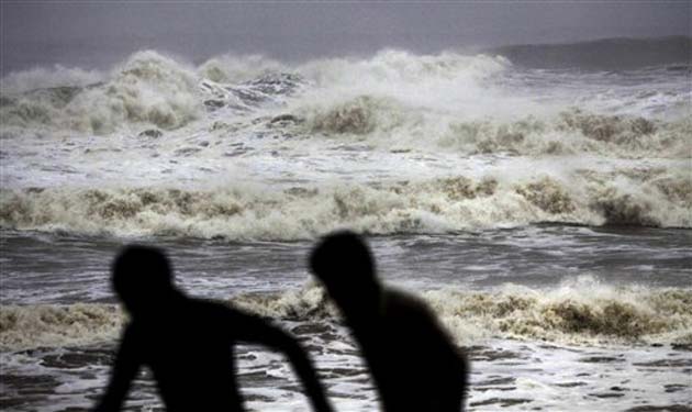
State of Sea: It will be very high along & off Odisha coast and very rough to high along & off north Andhra Pradesh and very rough along & off West Bengal coast during next 12 hours.
Action suggested: Fishermen are advised not to venture into sea along north Andhra Pradesh,
Odisha and West Bengal coast during next 24 hours. Judicious regulation of rail and road traffic in vulnerable areas. People in affected areas to remain indoors.
- Phailin has crossed much over into the interior area and will cross our state by evening
- 8,73,000 people have been evacuated so far and there are seven casualties
- Whatever we have tried we have reached our goal
- The next task is clearing roads, restore water supply and electricity and that will be done by evening
- There is no need to air drop relief materials but still, choppers are on stand-by
Paradeep pic.twitter.com/KuV8xNuUuW
- hridayesh (@hridayeshjoshi) October 13, 2013
- There seems to be a zero loss of life
- We combated this severe cyclonic storm under NDMA
- Forecast has been quite correct and very long time was given right from the cyclone's inception, both in terms of track and intensity
- Time and place of landfall which is most crucial accurately predicted which helped a lot
- The cyclone is currently placed at 50 km south of Sambalpur
- In Odisha, heavy to very heavy rainfall to continue for another 24 hours
- There is nothing to worry about in Andhra Pradesh
- Phailin will remain a severe cyclonic storm till noon
- By evening, it will become a cyclonic storm and by late evening it will become a deep depression
- In terms of winds, next 12 hours are crucial
- Winds will blow with a speed of 100-110 kmph gusting upto 120kmph over Odisha
- It is soon start decreasing and by evening, the windspeed it will be 60-70 kmph
- The worst in terms of winds is over and rainfall belt is moving as said in the forecast
- In Bihar, heavy to very heavy rainfall is expected in the next 48 hours
- On US warnings: They have been issuing warnings and we have been contradicting them that is all I want to say
- As a scientist we have our own opinion and we stuck to that. We told them that is what is required as national weather service to keep people informed with the reality without being influenced by over warning
- Focus will now shift to Jharkhand and Bihar
18 stranded fishermen rescued in Paradip
- Our teams have been working since before dawn to clear the roads
- Electricity and communication departments working to restore power and communication lines so that the state administration can reach out to get a real assessment
- If people are stuck in collapse structures or any other trouble, our teams can reach out to them
- In two districts of Andhra Pradesh, we got information that about 25-30 people were trapped so our teams were sent this morning
- More than 50 teams have been working in the two states and three other teams working in West Bengal as well, 20-30 teams on stand-by
- I think the big fury of the cyclone has passed, people in the cyclone shelters need to be taken back to their place where they make their living so that would be a giant task
- The cyclone that made landfall yesterday evening has gradually weakened and it has moved to the central part of Odisha
- The system is in the Phulbani area
- The winds are about 100 km, gusting upto 120 km
- There will be widespread rain in all over Odisha and parts of Andhra Pradesh
- On the whole, we are quite satisfied with the evacuation work that was done
- In Gopalpur, where the cyclone made landfall, almost 90-95% people have been evacuated
- The confirmed casualties are now 7 although there are few more
- The number is significantly lower than what it could have been because many have been shifted to cyclone relief shelters
- Severe damage reported in south Odisha, especially Ganjam and Puri
- In my district (Kendrapara), there is flooding
- Lot of the roads that have been blocked bring cleared by relief workers
- Once the wind dies down the air operations will begin
- The picture that I tweeted was of my team and some volunteers
- Efforts of Odisha government have been on in full swing for the last few days
- Doctors, medicines and food have been arranged in vulnerable districts
- We can be sure that damage is much less, and is connected only to property
- Relief will also be seen in full swing shortly
- The casualty figure will change as few places are still cut-off
- Some of these people have died not because of the cyclone, some others died in the shelters due to old age
- Power is down even in parts which were not at the centre of the storm
- We will have a clear picture in the next few hours once communication lines are restored
Time of issue: 0830 hours IST Dated: 13-10-2013
Bulletin No.: BOB 04/2013/37
Subject: Very Severe Cyclonic Storm 'PHAILIN' over Odisha
The very severe cyclonic storm, PHAILIN over Odisha moved northwards during past 3 hours
with a speed of 20 kmph and lay centred at 0530 hrs IST of 13 th October 2013 over Odisha near latitude 20.0 0 N and longitude 84.5 0 E, close to Phulbani. The system would move northwards for some more time and weaken gradually into a cyclonic storm by noon of today and into a deep depression by evening of today.
Estimated track and intensity of the system are given in the Table below:
Date/Time(IST) Position Sustained maximum surface Category
(Lat. 0 N/ Long. 0 E) wind speed (kmph)
13-10-2013/0530 20.5/84.5 130-140 gusting to 150 Very Severe Cyclonic Storm
13-10-2013/1130 21.5/84.5 80-90 gusting to 100 Cyclonic Storm
13-10-2013/1730 22.3/84.8 50-60 gusting to 70 Deep Depression
13-10-2013/2330 23.5/85.2 40-50 gusting to 60 Depression
14-10-2013/0530 24.8/85.7 35-45 gusting to 55 Depression
Warning for Odisha, Andhra Pradesh and West Bengal
Heavy rainfall: Rainfall at most places with heavy to very heavy falls at a few places and isolated extremely heavy falls (≥ 25 cm) would occur over Odisha during next 24 hrs and isolated heavy to very heavy fall during subsequently 24 hrs. Rainfall at most places with isolated heavy to very heavy falls would occur over north coastal Andhra Pradesh during next 24 hours and over Chhattisgarh, Jharkhand & Gangetic West Bengal during next 48 hrs.
Gale wind: Gale wind speed of 130-140 kmph prevailing at 0530 hrs IST would gradually decrease to 80-90 kmph by noon and further to 50- 60 kmph by evening of today over Odisha.
Damage expected over Odisha: Extensive damage to kutcha houses. Partial disruption of power and communication lines. Disruption of rail and road traffic. Potential threat from flying debris. Flooding of escape routes. Extensive damage to agricultural crops.
State of Sea: It will be very high along & off Odisha coast and very rough to high along & off north Andhra Pradesh and very rough along & off West Bengal coast during next 12 hours.
Action suggested: Fishermen are advised not to venture into sea along north Andhra Pradesh,
Odisha and West Bengal coast during next 24 hours. Judicious regulation of rail and road traffic in vulnerable areas. People in affected areas to remain indoors.
Govt sources say three deaths reported in Odisha; no casualty from Andhra Pradesh yet. Extensive damage to crops in Odisha's Ganjam district, communication lines down in several parts
- This system is very strong, gradually moving towards northwest
- It is still in the coastal districts
- Not getting data from Gopalpur
- Yesterday, it was completely powered off, some of the walls have collapsed there, communication lines down, no contact

 Cyclone Phailin spares Visakhapatnam, morning walkers throng beach
It's Sunday morning in Visakhapatnam. The road above the city's Ramakrishna Beach is full of morning walkers and the fitness conscious. Small fishing boats could be seen out on the waters under a grey sky.
- The city is coming back to life
- Last night, it was extremely windy with heavy rains
- This morning, the rain has stopped and wind has abated
- No loss of life reporte so far
- AUthorities say power supply will be restored by evening
- Lots of cars have stumbled over, trees and electricity poles have been damaged
- Administration have started to clear streets to restore road connectivity
- There is no power since last night, say locals
- Trains have not started functioning
 Coastal Andhra Pradesh escapes cyclone fury, no loss of life reported
As the morning after clears the air, quite literally, it seems the coastal areas in northern Andhra Pradesh managed to escape the fury of Phailin, which prompted India's biggest evacuation in 23 years.
- NDRF battalion placed in Berhampur has contacted the Headquarters
- No contact from Gopalpur so far
- Nature of damage:
Concrete constructions seem to have withstood the cyclone
- Road clearing mechanism is underway
- No loss of life reported so far
- mobile communication established till Berhampur
- Power supply continues to be down in most parts of Odisha
- Windspeed in down considerably, currently 45-50 kmph at Bhanjanagar and 45 kmph in Bhubaneswar
Subject: Very Severe Cyclonic Storm 'PHAILIN' over Odisha
The very severe cyclonic storm, PHAILIN over south coastal Odisha moved north-northwestwards during past 3 hours with a speed of 20 kmph and lay centred at 0230 hrs IST of 13th October 2013 near latitude 20.00 N and longitude 84.50 E, 90 km northwest of Gopalpur over Odisha. The system would move in north-northwestwards and weaken gradually.
Estimated track and intensity of the system are given in the Table below:
Date/Time(IST) Position Sustained maximum surface Category
(Lat. 0N/ Long. 0E) wind speed (kmph)
13-10-2013/02:30 20.0/84.5 160-170 gusting to 190 Very Severe Cyclonic Storm
13-10-2013/05:30 20.5/84.1 80-90 gusting to 100 Cyclonic Storm
13-10-2013/11:30 21.5/83.5 50-60 gusting to 70 Deep Depression
13-10-2013/17:30 22.5/83.0 40-50 gusting to 60 Depression
13-10-2013/23:30 23.5/82.5 35-45 gusting to 55 Depression
Warning for Odisha, Andhra Pradesh and West Bengal
(i)Rainfall at most places with heavy to very heavy falls at a few places and isolated extremely heavy falls (≥ 25 cm) would occur over Odisha and north coastal Andhra Pradesh during next 36 hrs. Isolated heavy to very heavy rainfall would occur over coastal areas of West Bengal during next 36 hrs.
Damage expected over Odisha and adjoining north Andhra Pradesh: Extensive damage to kutcha houses. Some damage to old buildings. Large scale disruption of power and communication lines. Disruption of rail and road traffic due to extensive flooding. Potential threat from flying debris. Flooding of escape routes. Extensive damage to agricultural crops.
Action suggested: Fishermen are advised not to venture into sea along north Andhra Pradesh, Odisha and West Bengal coast. Total suspension of fishing operations. Large scale evacuation of population from coastal areas. Total suspension of rail and road traffic in vulnerable areas. People in affected areas to remain indoors.
Post landfall outlook: System would weaken gradually into a cyclonic storm while moving north-northwestwards across interior Odisha. Under its influence rainfall at most places with heavy falls at a few places and extremely heavy falls at isolated places would occur over Odisha. Rainfall at many places with isolated heavy to very heavy falls would also occur over north coastal Andhra Pradesh, Chhattisgarh and Jharkhand.
Indigo airlines says its 7am Delhi - Bhubaneswar flight will take off at 8. Thank goodness, in '99 nothing moved for 3 days!!! #Phailin
- Baijayant Jay Panda (@Panda_Jay) October 13, 2013
- Business is usual, no rains overnight
- City spared the worst
- We've moved more than 5 lakh people to safer places
- 5-6 people cyclone-related deaths have been reported
- Though the IMD says wind speeds will come down, I still haven't seen that happening. Wind is still blowing at high speed
- It's morning, but feels like midnight. There is no power, communication lines are down.

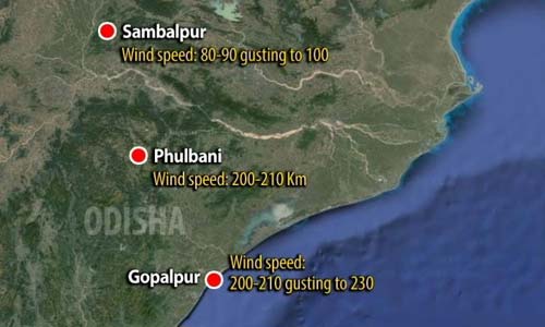
Very Severe Cyclonic Storm 'PHAILIN' over northwest adjoining west-central Bay of Bengal has crossed coast close to Gopalpur (Odisha).
The very severe cyclonic storm, PHAILIN over northwest adjoining west-central Bay of Bengal moved north-northwestwards during past 3 hours with a speed of 15 kmph and crossed Odisha & adjoining north coastal Andhra Pradesh near Gopalpur between 2030 to 2130 IST of 12th October 2013 and lay centred at 2330 hrs IST of 12th longitude 84.80 E, 25 km northwest of Gopalpur over south coastal Odisha. The system would move in north-northwestwards and weaken gradually.
Estimated track and intensity of the system are given in the Table below:
Date Time (IST) Position
12-10-2013 23:30 19.5/84.8 200-210 gusting to 230 Very Severe Cyclonic Storm
13-10-2013 05:30 - 20.5/84.1 80-90 gusting to 100 Cyclonic Storm
13-10-2013 11:30 - 21.5/83.5 50-60 gusting to 70 Deep Depression
13-10-2013 17:30 - 22.5/83.0 40-50 gusting to 60 Depression
13-10-2013 23:30 - 23.5/82.5 35-45 gusting to 55 Depression

- It's been more than eight hours since Cyclone Phailin made landfall
- The weather is still squally, winds picking up again
- Locals say the extent of the damage is not as much as initially believed
- Mobile connectivity still on
- Schools turned into relief centres
- Southern skies have cleared, electricity poles are still erect and fishermen's boats are alright
- Roads too are open and inundation has decreased
- Paradip under heavy cyclonic effect, wind blowing at very high speed, heavy downpour continues
- People remain inside the homes no one can move out
 Cyclone Phailin hits Odisha, high intensity winds in Berhampur
 With Cyclone Phailin making landfall in Odisha, high intensity waves are blowing in Berhampur. NDTV's Anchal Vohra gives a first person account of how strong wind howled across hitting closed doors and windows of houses and buildings.
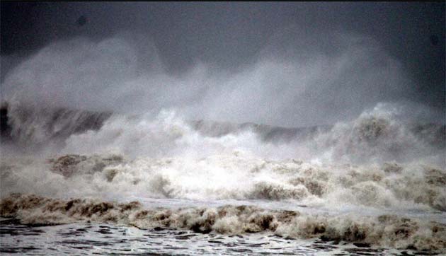
Cyclone Phailin hits Odisha at wind speed of 200 km per hour; over 7 lakh evacuatedThe monster cyclone Phailin, packing heavy rains and destructive winds, hit very close to Gopalpur on the Odisha coast shortly after 9 on Saturday evening, as over seven lakh residents moved inland to shelters in the hope of riding out the dangerous storm.
 Gopalpur, a scenic beach spot under spectre of death
On a bright autumn day, this famous beach in Odisha is a tourists' paradise as the lips feel the salt in the cool breeze from Bay of Bengal and its gentle waves splash at the feet.
 Cyclone Phailin not a super storm, says Met Department
Cyclone Phailin hit the Indian coast, a little south of Gopalpur in Odisha, between 8.30 to 9 pm today at a windspeed of 200 kilometres per hour, Indian Meteorological Department (IMD) officials said in New Delhi.
 Glass, wood, asbestos sheets flew as Cyclone Phailin struck Gopalpur
Broken glass pieces, wood shreds and asbestos sheets flew like killer projectiles in these two adjoining cities, moments after the severe cyclone 'Phailin' slammed into Gopalpur beach.
 Watch: Cyclone Phailin makes landfall with wind speed of 200 km per hour
 Cyclone Phailin, packing heavy rains and wind speeds of 200 kilometres per hour, slammed into the coastal town of Gopalpur in Odisha shortly after 9 pm today.
 Over seven lakh evacuated in Odisha, officials on high alert
Cyclone Phailin, packing heavy rains and wind speeds of 200 kilometres per hour, slammed into the coastal town of Gopalpur in Odisha shortly after 9 pm today. Sources in the Chief Minister Office say over 7 lakh people had been evacuated today before the "verey severe" storm struck.
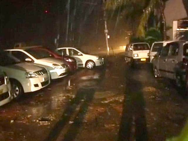 Cyclone Phailin: no electricity, heavy rain in Bhubaneswar
In Bhubaneswar, the intensity of the rain has gone up since 7 pm and strong winds are blowing.
 Cyclone Phailin to maintain intensity for next six hours: Met department
Cyclone Phailin, which made landfall with a wind speed of 200 kmph near Gopalpur town in Odisha tonight, is likely to maintain the intensity of a very severe cyclonic storm for six hours, the Met department has said.
- Wind speed still very high all along coast
- Sea wave height rise was not as anticipated, it has helped
- Chief Minister asks teams across the coast to alert through the night and ensure no human movement
- Exactly 7.2 lakh people along the coast evacuated before 4 pm on Saturday
- Chief Minister Naveen Patnaik to hold a review meeting at 10:30 am on Sunday
- All district collectors will be present at the review meeting via video-conferencing
- After meeting, teams will fan out across the affected districts
- Teams to assess damage and need for relief on Sunday morning
- State government control room getting reports of flooding in several areas
- Teams already prepared to tackle flooding
- Andhra Pradesh Chief Minister Kiran Kumar Reddy directs chief secretary and administration to be on high alert
- Chief Minister also orders commencement of repairs and restoration of electricity, roads, sanitation and drinking water schemes etc.
- Chief Secretary to review situation in high-level meeting at 10.30 am on Sunday followed by a review meeting by Chief Minister at 12.30 pm
1 in Bhubaneswar
2 in Ganjam
2 in Jagatsinghpur
Reports of several trees being uprooted in Bhubaneswar and the highway connecting Gopalpur, vehicular traffic hit
- Cyclone will take an hour to cross the coast
- Wind speed of cyclone at time of landfall is 200 km/hr, marginally less than expected
- Storm surge at landfall is 3-3.5 metres
- Phailin to remain "very severe" cyclone for six hours after landfall
- From Gopalpur to Paradip there are gale winds, it (the danger zone) will be around 150 kilometres
- Heavy to very heavy rainfall reported in Odisha and north
coastal Andhra Pradesh
 Cyclone Phailin makes landfall near Gopalpur on Odisha coast
 Cyclonic storm Phailin, classified as "very severe", has made landfall near Gopalpur in Odisha. The cyclone has prompted the country's biggest evacuation in 23 years with more than 5.5 lakh people moved up from the coastline in Odisha and Andhra Pradesh to safer places.
 Centre ready with choppers, aircraft, ships for rescue
18 helicopters, 12 aircraft and two war ships have been kept ready by the government for rescue and relief operations in Odisha and Andhra Pradesh which are facing the brunt of cyclone 'Phailin'.
- Around 62,000 people evacuated and accommodated in 56 relief centres
- Another 20,000 accommodated in cyclone shelters in upland areas
- No major incident reported till now
- 30 people stuck in Vonturu in Kaviti Mandal at a higher level. Special Officer PD DRDA is in touch with them. NDRF team of Rajapuram shall rescue them immediately after the cyclone passes away
 Chhattisgarh issues alert as heavy rains expected
Chhattisgarh government has issued an alert to all its departments in view of the cyclone Phailin which is likely to trigger heavy rainfall and thunderstorms in the area between south Bastar and the capital Raipur.


- Over 5.5 lakh people evacuated in Odisha, Andhra Pradesh
- Phailin will hit the Gopalpur district in Odisha first,it will affect roads and power services
- Many people refused to move, have to be convinced
 Cyclone Phailin triggers India's biggest evacuation operation in 23 years
Cyclone Phailin, being described as possibly the biggest cyclone ever to hit India, has triggered India's biggest evacuation programme in 23 years, reports said today.
PM directs all possible assistance to the States concerned in ensuring the safety of the people & in relief and rescue operations. #Phailin
- Dr Manmohan Singh (@PMOIndia) October 12, 2013
PM was briefed by the Cabinet Secretary on the arrangements that have been put in place to deal with the impact of the cyclone. #Phailin
- Dr Manmohan Singh (@PMOIndia) October 12, 2013
On Ashtami night let's also pray for the safety of the people of Odisha &Andhra Pradesh, as Cyclone Phailin nears the East Coast.
- Shashi Tharoor (@ShashiTharoor) October 12, 2013


 Cyclone Phailin hurtling towards Odisha, Andhra Pradesh coasts; expected to make landfall between 6 and 8 pm
Cyclonic storm Phailin, the strongest to hit India in more than a decade and classified as 'very severe' so far, is about 70 km away from Gopalpur in Odisha. It is expected to hit parts of the state and neighbouring Andhra Pradesh between 6 and 8 this evening.
 Cyclone Phailin: 'PM said all steps must be taken'
 Cabinet Secretary Ajit Seth speaks exclusively to NDTV about the state of preparedness ahead of Cyclone Phailin.
- We have evacuated 4,48,000 people
- 46 NDRF teams mobilized
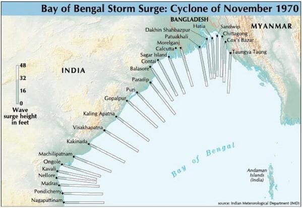
 A look at devastating cyclones from Bay of Bengal
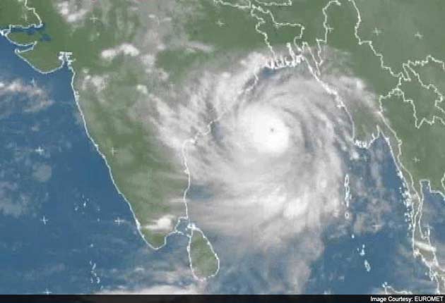
Cyclone Phailin is expected to cause extensive damage in eastern India, with a storm surge that will flood low-lying areas and heavy rains and strong winds that will last for hours. Here are some details on other devastating cyclones that have formed in the Bay of Bengal
 Post landfall, 'very severe' cyclone to last for 6 hours: Met department Video: NDTV.com
LS Rathore, Director General, IMD, says:
- Cyclone Phailin 90 kilometres away from Gopalpur, still very severe
- Expect heavy to very heavy rain fall in Odisha and North Andhra Pradesh
- Very, very heavy rain fall expected in Odisha, over 25 cm
- The cyclone will be severe for 6 hours after landfall
- It will be a depression after that
- The cyclone is advancing with a speed of 20km/hour towards Gopalpur
- You have been saying IMD is underestimating cyclone Phailin, why can't you say US is overestimating it
- We are estimating a sustained speed of 220kmph at landfall
- If the sustained speed goes beyond 220kmph it is called a super cyclone
- It is close to a super cyclone
- In 1999 cyclone - wind speed was 260km/hr and storm surge was six metres.
- First priority to save lives
- Evacuation is over
- 400,000 people evacuated so far
- Most from Ganjam district
- There was some resistance
- We had force people in some areas
- Communication sets - satellite phones and radios distributed to key points
- We hope causalities will be much less than 1999
 President Pranab Mukherjee cuts short his Bengal visit
President Pranab Mukherjee, who is at his ancestral home in West Bengal for Durga Puja, has cut short his visit and will return to New Delhi today in view of Cyclone 'Phailin' that is set to hit Odisha coast.
Cyclone Phailin is moving north-westwards with speed of 15 kmph and is centered about 120 km southeast of Gopalpur. Danger signal 10 has been issued for Gopalpur and Puri ports in Odisha. Danger signal 9 has been issued for Paradip and Chandbali ports, says IMD
- Raining very heavily, winds strong
- People still being evacuated from interiors
- THe Dictroct Collector has given the orders to forcibly evict people
- Winds of 120 to 130 km in Srikakulam
- Power supply cut from Ichchapuram to Palasa
- Road transport too suspended in those areas
- Waters level in rivers Vamsadhara and Nagavalli may rise above danger mark
 All trains between Howrah and Visakhapatnam cancelled
With cyclone Phailin set to hit Odisha and Andhra Pradesh coasts this evening, the Railways have cancelled all trains between Howrah and Visakhapatnam as a precautionary measure.
- The cyclone is located 180 km off Gopalpur is what I am told
- 3,60,000 people have been evacuated from Odisha
- The track of the cyclone is more or less in and around Gopalpur
- Heavy rains have started and will further intensify
- Our damage assessment is same as done by the Indian Meteorological Department
- NDRF teams have been deployed
- Request for additional teams in Andhra Pradesh which will be made available
- Ganjam in Odisha expected to be the most affected, we have deployed 40% of our resources there
- PM will be returning today, we will brief him on all the updates
- 1200 NDRF personnel deployed in Odisha; 600 in Andhra Pradesh
- Our priority is to minimise casualties
- Highest evacuation was in 1990 in Andhra Pradesh where 6 lakh people were evacuated
- The local administration needs to instruct people, we need to create that awareness and at times even force is used
- Loss of property is inevitable
- On the whole, about 4 lakh people have been evacuated from Andhra Pradesh and Odisha
- I spoke to both the Chief Ministers (Andhra and Odisha) and also the ministers from both the state
- Control rooms are touch with the Collectors in districts which are expected to be worst affected
- Cyclone shelters are not the only place where people are evacuated to, camps are also set up at different locations based on availability
- These are for a shorter period of time
- They have also identified 1000 safe buildings in Odisha to relocate the evacuees
- The US Coast Guards and NOAA have downgraded this cyclone this morning
- The IMD has been accurate with providing figures in the past
- The loss of life during Cyclone Katrina was high because people did not abide by the advisories but we have better technology and resources now and I believe we will be able to minimise loss of life
- We are well prepared
Asked our state disaster management team to be ready to extend every possible help to authorities in the wake of cyclone on eastern coast.
- Narendra Modi (@narendramodi) October 12, 2013
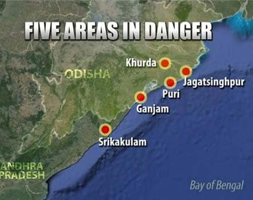
- Navy alerted 60 diver teams, which are in place at Vizag. More than three lakh people have been evacuated from five districts of Odisha and Andhra Pradesh namely Ganjam, Jagatsighpur, Khorda, Puri and Srikakulam.
- Air Force has air-lifted 528 tonnes of relief material
- Bhubaneswar airfield has been closed, all aircraft moved up and are available on call
- Andhra Pradesh wanted 10 helicopters and those are being made available
- Odisha wants little more effort from the NDRF and it is being provided
- Army has moved in engineers from various locations
- A core team of the armed forces has been created at Bhubaneswar. It is being headed by a 3-star General who has already been moved in from Jabalpur
On post-cyclone situation:
- The biggest problem is evacuation and sheltering
- Odisha and Andhra Pradesh are slightly better prepared now
- Odisha has been practising mock drills so they are better prepared
- A plan is in place for restoration, NDMA is prepared
- Tree chopping devices to clear roads are in place
- Restoration of electricity, water supply, communication lines and emergency services are the biggest challenges and top priorities post-cyclone
 As Cyclone Phailin approaches, over three lakh evacuated in Odisha
 Experts say the wind speed is gusting at 210 to 220 km per hour and is expected to touch 240 km per hour when the cyclone makes landfall.
L S Rathore, DG, MeT department
- Intensity of winds and rainfall will increase as the day progresses
- It has been moving in a north-westwardly direction
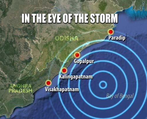
- It is likely to hit between Kalingapatnam and Gopalpur
- Gusty winds of the order of 65-75kmph reported from the coast of Odisha
- Heavy rain has been reported from coastal Odisha
- At the time of crossing the coast, the wind speed will remain as severe cyclonic storm
- Winds with speeds between 210-220kms will be experienced. Speeds could rise to 240 kms
- Heavy to very heavy rainfall in northern coast of Andhra Pradesh is also expected
- Storm surge is likely between 3-3.5 mt
- Jharkhand and Chattisgarh will also get isolated-heavy to very heavy rain
- Moderate rainfall is expected in west Bengal
- Phailin likely to hit between Kalingpatnam and Paradip at Gopalpur this evening between 6-8pm
- Landfall between 6 pm to 8 pm near Gopalpur
- Phailin will remain as severe cyclonic storm for 6 hours after it hits
 52,000 people evacuated in Srikakulam in Andhra Pradesh
As many as 52,000 locals were today evacuated and 25,000 people accommodated in cyclone shelters in Srikakulam district in view of Cyclone Phailin which is expected to cross the shore by this evening.
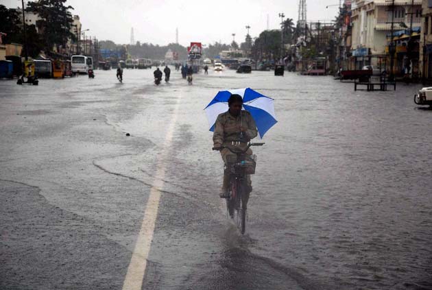
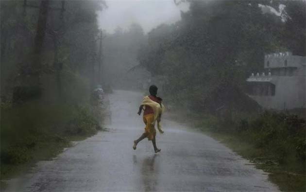
 Heavy rain lashes Odisha as Cyclone Phailin advances
High wind and heavy rain lashed the coastal belt of Odisha on Saturday disrupting normal life, as 'very severe' cyclonic storm Phailin advances from the Bay of Bengal. The cyclone is expected to make landfall by Saturday evening, officials said.
 Cyclone Phailin: a look at numbers that underscore the impact
'Very severe' cyclone Phailin barrels fiercely towards coastal Odisha and Andhra Pradesh at wind speeds averaging 200 km per hour and is expected to hit the coast at 6 pm today.
 Cyclone Phailin closes in on Odisha, Andhra Pradesh coasts; forces mass exodus
 The storm, likely to affect around 1.2 crore people, has triggered mass exodus in at least seven districts of the two states.
Chief Minister Kiran Kumar Reddy will be holding a meeting with ministers and officials at 12 noon.
 Phailin, strongest cyclone since 1999, shows no sign of weakening
The Indian Meteorological Department warned that Phailin was a "very severe cyclonic storm" that was expected to hit with maximum sustained winds of 210-220 kilometers (130-135 miles) per hour.
Paradip Port has shut down cargo operations since yesterday night. All vessels at the port have sent back into deep sea. Port workers have been moved out. Odisha is still in the process of evacuating 200, 000 people. Cyclone Phalin is still about 255 kms away from Pradip port.
Eastern Naval Command has kept multiple Indian Navy diving teams with inflatable rafts in standby mode at important locations which could be put into operations at short notices
Navy has also put some Chetak and UH-3H helicopters in standby for launching rescue and relief operations, if necessary.
- More than one lakh people in Odisha and 64 thousand people in Andhra Pradesh have been evacuated. Odisha will evacuate 5 lakh more as cyclone approaches.
- 1600 NDRF personnel have been deployed in Odisha and Andhra Pradesh. 14 teams consisting of 559 personnel and 37 boats have been deployed at different locations in Andhra Pradesh and 23 teams of 950 personnel and 80 boats have deployed at different locations in Odisha.
- Srikakulam in Andhra Pradesh and Ganjam, Puri, Khordha, Jagatsinghapur in Odisha are the worst affected areas. Nearly 1.2 crore people will affected by the cyclone.
- Red alert has been sounded and the striking revenue officials have reported for ground work in five districts.
- Odisha has targeted 'zero casualty'. 24 passenger trains have been cancelled in Andhra Pradesh.
 West Bengal takes steps to manage aftermath of Cyclone Phailin
West Bengal government has dispatched disaster management teams to coastal areas of the state to tackle the aftermath of cyclone Phailin which is set to hit neighbouring Odisha by tomorrow evening.
 As Cyclone Phailin advances, Odisha coast being evacuated
Odisha today launched a massive drive to evacuate coastal villages as the severe cyclonic storm Phailin advanced from the Bay of Bengal. Phailin is expected to make a landfall on Saturday evening.
 Cyclone Phailin: is India prepared?
 As the east coast of India braces for Cyclone Phailin, we discuss have we learnt any lessons after the 1999 Odisha super-cyclone.
 India braces for super storm
 Even as Andhra Pradesh reels from a political storm, a massive cyclone that has been building up in the Bay of Bengal threatens the coastal districts of the state and it's neighbour, Odisha. The state governments and NDRF forces have scrambled to evacuate lakhs of people, and prepare for a mega-storm that many experts fear will dwarf the fearsome Hurricane Katrina that devastated New Orleans in 2005. Has the Met Department underestimated the power of Cyclone Phailin or will the measures taken save the lives and livelihoods of lakhs of Indians? We discuss.
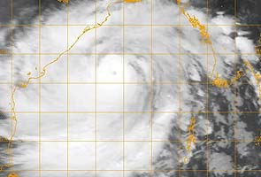
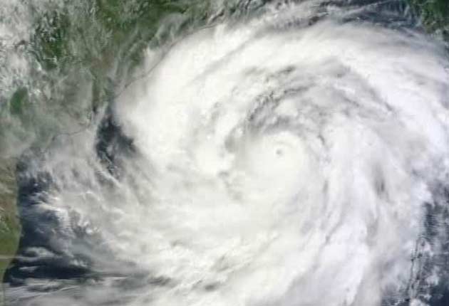
Latest view of #Phailin from India's Kalpana satellite: pic.twitter.com/eVSJI6BbsH
- Eric Holthaus (@EricHolthaus) October 11, 2013
 All employees back at work for Cyclone Phailin: Andhra Pradesh Chief Minister
Andhra Pradesh Chief Minister Kiran Kumar Reddy tells NDTV that the disaster from the 'very severe' Cyclone Phailin could be unprecedented and that 64,000 people are being evacuated.
- Disaster could be unprecedented, 64000 people being evacuated
- All employees back at work for cyclone Phailin, grateful to them
 Nearly 1.2 crore people likely to be affected: Disaster management authority
Cyclone Phailin is expected to affect around 1.2 crore people in more than five states, the National Disaster Management Authority (NDMA) said today.
 Cyclone Phailin: how Odisha is bracing for the 'very severe' cyclonic storm
When Cyclone Phailin strikes the coastal areas of Odisha and Andhra Pradesh tomorrow evening, the lives of nearly 1.2 crore people are expected to be affected.
 Paradip Port in Odisha shuts operations
Paradip Port today shut all cargo operations, plants and machinery and put in place a contingency plan to meet any eventuality due to Cyclone Phailin which is expected to hit eastern coast tomorrow.
- Chief Minister Naveen Patnaik overseeing entire preparedness and relief bandobast
- State government to evacuate two lakh people by tonight, largely from six districts
- Chief Minister discuss evacuation, relief via video-conferencing with all district collectors
- 1999 cyclone relief was hit by poor communication, one or more satellite phones operational at all vulnerable districts
- Police wireless system beefed up as back-up for communication failures
- Elected representatives - MLAs to sarpanches - directed to be on field to ensure proper evacuation and cyclone shelter arrangement
- Cooked food to be supplied at all relief shelters tonight as evacuees won't have provisions
- Mass kitchens set up at all shelters
- Dry food packets readied for post-cyclone scenario
#Phailin just officially reached Category 5 status. 140kts, 918mb central pressure. Same as 1999 cyclone at its peak. http://t.co/MNJcggKEkd
- Eric Holthaus (@EricHolthaus) October 11, 2013
- Army Aviation assets on standby at Nasik, Bangalore and Ranchi
- An engineer column being airlifted from Allahabad to Bhubaneswar
- Command and control elements from Chhattisgarh and Odisha sub-area headquarters to be airlifted to set up advance headquarter at Bhubaneswar
- Elements of entire madhya bharat area likely to be incorporated in rescue operations
- The PM has expressed his concern on the developing situation on the cyclone
- The PM has said that the government will give all necessary help to all the affected states
- I spoke with all the CM's, they seem to be satisfied with the efforts at our end
- IMD has given all technical details
- 1.2 crore people to be affected, people should take warnings seriously
 Not right to call Phailin super-cyclone yet: Met department
Dr LS Rathore, Director General, IMD says:
- The very severe cyclonic storm has been moving north-westward
- Wind speeds of 200 kmph, gusting upto 230 kmph
- Expect heavy to very heavy rainfall
- Some parts of Odisha may get extremely heavy rainfall - above 25 cm in 24 hours
- It is currently 450 kilometres from Gopalpur
- Rainfall has already started in coastal Andhra Pradesh and Odisha - it will further intensify in the evening
- Rainfall expected in North Chhattisgarh and South Jharkhand. Also, in Gangetic West Bengal, Eastern UP and Bihar
- Storm surge of around three metres is likely around the Odisha coast
- Super cyclone is above 220 kmph and gusting upto 250, so this is touch and go. We are monitoring closely and don't expect further intensification
- Consciously and strictly monitoring the situation
- Don't contemplate that it will intensify further. It will remain a 'very severe' cyclone
- Chilka is also likely to be impacted
- Communication towers may be impacted. Coastal areas may be inundated
- Expect disruption of road and rail traffic due to flooding
- We have issued warnings to all stakeholders including Odisha and Andhra Pradesh governments
- Not right to call Phailin super-cyclone yet
- Evacuation process has already begun
Engineers' column from Bagdogra and medical columns from Gopalpur are moving towards Bhubaneshwar. Sufficient infantry relief columns also on stand by for any eventuality.
- Severe cyclone is at the distance of 520 km from Bay of Bengal
- The height of the waves is expected of 3 metres
- In 1990, the Cyclone in the southern region of Odisha was having the wind speed of 100 km per hour. Now it is expected more than 200 km per hour.
- If any officer would not perform his duty or would not visit on the site than we will not suspend him we will dismiss him from the job
- We will also appeal to the people not to come out of their houses at the time of cyclone
- We will evacuate the people to be affected and reside them somewhere else and will provide everything to them there only
- We are trying to fight with it but not without the help of the people
- We have already provided the food articles like Dry fruits
- We have enough stock of the Diesel and Petrol, so people can purchase as much as they can
- If businessmen try to misuse this situation then we will start arresting them
 Phailin gains strength, wind speed to reach 215 kmph: Met department
The severe cyclonic storm Phailin over east central Bay of Bengal today further intensified and is all set to make a landfall close to Gopalpur in Odisha at a wind speed of at least 205 kmph tomorrow.
 Andhra Pradesh gears up to face Phailin cyclonic storm
The Andhra Pradesh government is gearing up to deal with the impact of the cyclonic storm 'Phailin', which is expected to cause damage in coastal districts of the state.
 'Very severe' Cyclone Phailin heads for Odisha, Andhra Pradesh at wind speed of 200 kmph
 Some weathermen are describing it as potentially India's version of 'hurricane Katrina', one of the deadliest storms in US history.
- It has centered around 500 kms from Odisha.
- It will cross the coast between north Andhra and Odisha border at kalingapatnam.
- People will experience heavy to extremely high rainfall from today night.
- The current wind speed is 205 km/hr
The name Phailin (pronounced pie-leen) means a Sapphire. The cyclone has been named by Thailand
 Cyclone Phailin the size of Katrina: foreign media
The Washington Post said: "Potentially catastrophic cyclone Phailin, size of Katrina, headed for India"
 Cyclone Phailin approaches Andhra Pradesh, Odisha with wind speed of 200 km per hour
Cyclonic storm "Phailin", classified as "very severe" by the weather department, is expected to hit coastal Odisha and Andhra Pradesh at around 5:30 pm on Saturday. In Odisha, officials fear the wind speed could touch levels higher than that of the deadly super-cyclone in 1999 when nearly 15,000 people died.
It's already raining heavily in parts of Andhra Pradesh and Odisha. Coastal districts of the states are on high alert. Winds with speed of 45 to 50km per hour blowing along the coast.

The Army is on stand-by and ready for deployment at short notice in the two states
It would continue to move northwestwards and cross north Andhra Pradesh and Odisha coast between Kalingapatnam and Paradip by night of October 12
Fishermen of Andaman Nicobar Islands advised not to venture into the sea during next 48 hrs
With fear gripping people in Odisha at the approach of severe cyclonic storm 'Phailin' to Gopalpur on October 12 where it would make landfall, the Indian Meteorological Department (IMD) today affirmed it would not be a super cyclone.
- Cyclone Phailin is expected to hit at a windspeed of 175-185 kmph
- The impact will be felt in a radius of 250 kilometres.. so it's a 500 kilometre span
- Ganjam, Puri, Gajpati, Khurda, Jagatsinghpur will feel the impact
- Gopalpur in Ganjam district is in the eye of the storm
- The cyclone is moving north and the more it moves north, the more it impacts Odisha
- The state has been working on it for 6-7 days
- Our aim is to ensure that there are no casualties
- Everyone within 5 kilometres will be evacuated and those who refuse will be shifted forcibly.
- Special shelters have been set up which will provide food and water. The aim is to restore road connectivity within 12 hours.
 Cyclone Phailin intensifies into severe storm, high alert for Andhra Pradesh, Odisha
The cyclonic storm "Phailin" which hit the Andaman and Nicobar Islands on Wednesday has intensified into a severe cyclonic storm and is heading towards coastal Odisha and Andhra Pradesh where it is expected to hit on Saturday night.
- We are in touch with state governments and informed them in advance
- We have pre-positioned NDRF team - 28 of these are in Odisha and 15 in Andhra Pradesh for evacuation
- We have made all arrangements so that damage to life and property is minimised
On Andhra Pradesh agitation:
- We have appealed to them to get back to work and end the strike
- We have written to TDP president Chandrababu Naidu to end the fast
- We have also asked Jagan Mohan Reddy to give up
- Everybody has to come together
 Cyclone Phailin intensifies, high alert for Andhra Pradesh, Odisha
A high alert has been declared for all nine coastal districts of Andhra Pradesh. Evacuation plans are being worked out.
- We will send evacuation teams on a request by state government
- It is likely to become very serious by 12 October
- We may have winds which may gush to 200kmph and create extreme damage. This will cause landfall.
- 8 disaster management teams have been deployed. Additional teams will be sent on request
- We have battalions in Guntur which is likely to be affected
- At this point, the state govt should be ready for large scale evacuation
- I appeal to the employees to stop the agitation for the time-being
- This is not going to be done just by revenue department. Everyone should come together
- All the employees from different departments should go back to their duties
- We have to save the people and their properties
- The situation may turn serious. So I appeal to them to stop their agitation and help the situation
IMD is equipped with satellites and Doppler Radars that can accurately track the cyclone and predicting its land fall.
It is expected to continue to move northwestwards and cross north Andhra Pradesh and Odisha coast between Kalingapatnam and Paradip by night of 12thOctober, 2013 as a very severe cyclonic storm with a maximum sustained wind speed of 175-185 kmph.
The IMD has issued a cyclone alert for North Andhra Pradesh and Odisha Coast and a cyclone warning for Andaman & Nicobar Island.

