Surface Water And Ocean Topography Satellite
- All
- News
-

SWOT Satellite Observes Seismic Tsunami Event in Greenland’s Dickson Fjord
- Friday November 1, 2024
- Written by Gadgets 360 Staff
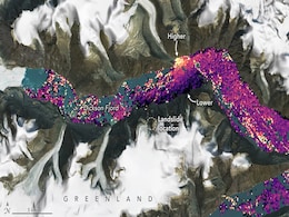
The Surface Water and Ocean Topography (SWOT) satellite, a joint mission by NASA and France’s CNES, has observed a significant tsunami event in Greenland’s Dickson Fjord. Triggered by a massive rockslide in September 2023, the tsunami lasted for nine days and generated seismic signals recorded globally. The satellite's advanced radar technology...
-
 www.gadgets360.com
-

NASA Launches Satellite For Landmark Study Of Earth's Water
- Friday December 16, 2022
- World News | Agence France-Presse
A satellite lifted off Friday from California on a mission to survey nearly all bodies of water on Earth, offering key insights on how they influence or are impacted by climate change.
-
 www.ndtv.com
-

SWOT Satellite Observes Seismic Tsunami Event in Greenland’s Dickson Fjord
- Friday November 1, 2024
- Written by Gadgets 360 Staff
The Surface Water and Ocean Topography (SWOT) satellite, a joint mission by NASA and France’s CNES, has observed a significant tsunami event in Greenland’s Dickson Fjord. Triggered by a massive rockslide in September 2023, the tsunami lasted for nine days and generated seismic signals recorded globally. The satellite's advanced radar technology...
-
 www.gadgets360.com
-

NASA Launches Satellite For Landmark Study Of Earth's Water
- Friday December 16, 2022
- World News | Agence France-Presse
A satellite lifted off Friday from California on a mission to survey nearly all bodies of water on Earth, offering key insights on how they influence or are impacted by climate change.
-
 www.ndtv.com


