From the top of the world to near the bottom, freakish and unprecedented weather has sent temperatures soaring across the Arctic, whipped the United Kingdom with hurricane-force winds and spawned massive flooding in South America.
The same storm that slammed the southern United States with deadly tornadoes and swamped the Midwest, causing even greater loss of life, continued on to the Arctic. Sub-tropical air pulled there is now sitting over Iceland, and at what should be a deeply sub-zero North Pole, temperatures on Wednesday appeared to reach the melting point - more than 50 degrees above normal. That was warmer than Chicago.
Only twice before has the Arctic been so warm in winter. Residents of Iceland are bracing for conditions to grow much worse as one of the most powerful storms ever recorded blasts through the North Atlantic. This rare "bomb cyclone" arrived with sudden winds of 70 miles per hour and waves that lashed the coast.
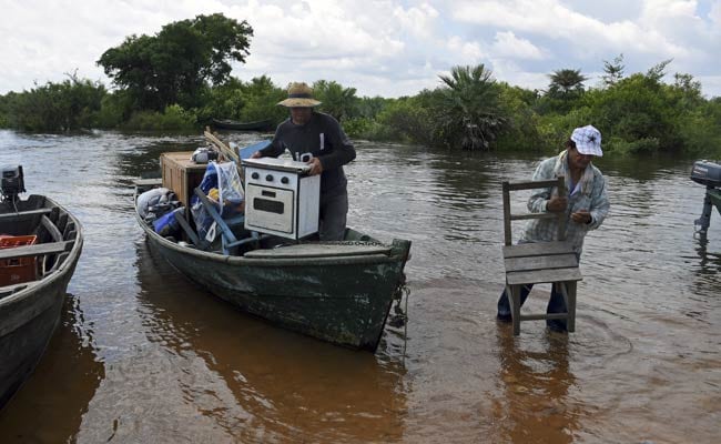
Thousands of miles south, in the center of Latin America, downpours fueled by the Pacific Ocean's giant El Niño pattern have drenched regions of Paraguay, Argentina, Brazil and Uruguay.
In what's described as the worst flooding in a half-century, more than 160,000 people have fled their homes. The Paraguay River in that nation is within inches of topping its banks, and the Uruguay River in Argentina is 46 feet above normal, according to a BBC News report.
The dramatic storms are ending a year of record-setting weather globally, with July measured as the hottest month ever and 2015 set to be the warmest year.
Up and down the U.S. East Coast, this month will close as the hottest December ever. In much of the Northeast into Canada, temperatures on Christmas rose into the 70s - tricking bushes and trees into bloom in many locations. In the Washington area, forsythia, azaleas and even cherry blossoms were suddenly in full color.
"I see this as a double whammy," Michael Mann, a professor of meteorology at Penn State University, said in an email. "El Niño . . . is one factor, human-caused climate change and global warming is another. You put the two together, and you get dramatic increases in certain types of extreme weather events."
The impact is more and more devastating.
In rain-soaked Missouri, where more than a dozen people have died because of the flooding, Gov. Jay Nixon (D) has declared a state of emergency.
Almost two dozen levees along the Mississippi River are considered at risk, and forecasts are calling for record or near-record crests of the river and tributaries that feed it. Nearly 450 river gauges have hit flood stage since Monday, according to the U.S. Geological Survey.
From Illinois to Texas, 6 to 12 inches of rain have fallen since Dec. 26. Dozens of new precipitation marks were set last weekend, in some cases doubling or even tripling old records.
"Major to historic" river flooding is predicted in St. Louis through Sunday, according to the National Weather Service. The Mississippi River, which cuts through the heart of the city, is expected to hit 13 feet above flood stage - one of the top three crests ever.
And downstream in Chester, Illinois, the river is likely to reach just below the 50-foot level of the Great Flood of 1993 - which, as the National Oceanic and Atmospheric and Administration's Office of Hydrology recounts, "simply overwhelmed everyone and everything."
What is most remarkable about this week's flooding through the nation's midsection is not the magnitude, but the timing. Under normal circumstances, this degree of wintertime flooding is not possible because there is not enough moisture in cold winter air to support such rainfall totals.
Although river levels will begin to drop over the weekend, the floodwaters will continue to move downstream on the Mississippi through mid-January. There they will meet runoff from excessive rain in the Southeast. Memphis; Vicksburg, Mississippi; and Baton Rouge, Louisiana, are all braced for significant flooding.

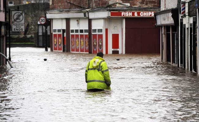
A man wades through floodwater in a street in Dumfries, southern Scotland, on December 30, 2015 after heavy rainfall brought by Storm Frank. (AFP Photo)
In England, Scotland and Northern Ireland, the scenes have been similar much of this week as storms made the month the wettest December in some locations. Hundreds of people were evacuated in York, where rushing water engulfed cars. Rescue operations were needed to remove some residents from flooded homes and to deliver food and medical supplies to others.
Homes in Yorkshire were left without power, and downed telephone lines halted phone service. BBC News reported that 100 people spent Tuesday night in barracks usually used to house security personnel who guard the queen during visits to Scotland.
Ben G. Kopec, a researcher at Dartmouth University who recently authored a study on how the loss of Arctic ice contributes to precipitation, acknowledged Wednesday that it is impossible to know specifically what is causing the radical weather swings.
Yet balmy Arctic temperatures are exceptionally rare in December, when sea ice is normally expanding in an unbearably cold climate so that it can endure through hotter months. "These temperatures are keeping sea ice from growing to set up for summer months," when it is needed as a counterbalance to the sun's radiation and to offset warming, Kopec said.
Whether the latest events can be linked to climate change will remain a question mark until research can be done, said Jeff Masters, the founding meteorologist of the weather website Weather Underground.
"We have trouble making that connection in real time, because we have trouble teasing out the natural variability from the human-caused forcing," Masters said Wednesday. "It's really hard to scientifically say that's what's going on."
Yet after decades of studying and analyzing global weather extremes, Masters thinks the shift is obvious. "This isn't the climate I grew up with," he said. "We didn't see this kind of weather in the 20th century. It's just a continuation of the crazy weather we've seen over the course of the 21st century so far."
At the moment, the pattern being exacerbated by El Niño, a naturally occurring cycle of very warm water in the equatorial Pacific. It typically triggers heavy rain in some areas and unseasonable warmth in others. By some measures, this year's El Niño is already the strongest on record.
Nicola Maxey, a press officer from the United Kingdom's national weather service, the Met Office, also noted that it is "still too early to say definitively" whether global climate change produced December's record rainfall.
However, she added via email, "all the evidence from fundamental physics and our understanding of our weather systems suggests there may be a link."
© 2015 The Washington Post
Track Latest News Live on NDTV.com and get news updates from India and around the world

